GEORGE TOWN: THE controversy surrounding the Bukit Relau illegal hill clearing in Penang has taken a new twist after documents showed that the DAP-led state government had rezoned the green area from reserve land to residential land.
The shocking revelation comes after a letter from the state Town and Country Planning Department to the landowners was adduced in a defamation suit hearing on Friday.
In the letter dated Dec 3, 2012, the department informed the landowner, General Accomplishment Sdn Bhd, that their appeal to rezone the 986m hilltop was approved by the State Planning Committee (SPC). The SPC is chaired by Chief Minister Lim Guan Eng.
“Based on the decision by the SPC No. 10/2012 dated Nov 20, 2012 and approved on Dec 3, 2012, we state that the committee agrees to approve the application to rezone the area to housing,” the letter read.
It was signed by Penang Town and Country Planning director Zainuddin Ahamad and copied to the Penang Island Municipal Council’s Town and Country Planning Department.
Lim was not available for comment. It was previously reported in an English daily that the surrounding 23ha hill was rezoned from hill land to low-density housing land in 2012.
However, the daily cited sources and the letter was not sighted until now.
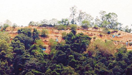
Between February and May 2013, a football-field sized portion (0.8ha) of Bukit Relau facing the Penang Bridge was cleared.
In June 2013, after a downpour, the retaining wall of a under-construction housing area at the foot of the hill gave way.
A row of existing terrace houses was slightly damaged. The Penang Island Municipal Council responded by saying that the landowners had started work without a Commencement of Work certificate and was illegal.
They, however, did not respond to queries if rezoning had taken place.
After public outcry over the hill top being cleared without the council’s approval, the landowner was fined.
The Penang Sessions Court found that General Accomplishment had failed to submit an earthworks plan as required by Section 70A of the Street, Drainage and Building Act 1974.
It was slapped with a RM30,000 fine. The amount was later raised to RM50,000.
The landowners were told to adhere to special mitigation steps recommended by the state’s Hillside Geotechnical Advisory Panel to reverse the damage on the site.
The hill has since earned the moniker “Bukit Botak” (bald hill).
Until today, the hill appears to be “bald” despite works to replant trees at the area.
Today, the barren hilltop remains an eyesore and is visible from the Penang Bridge.
Last June, Bukit Kukus, on the same range as Bukit Relau, was cleared. Land about the size of a football field was cleared close to the densely populated Taman Paya Terubong Jaya housing estate.
The area being cleared was 1,200 feet above sea level, causing many to ask how anyone could have approved a development project at the site. The authorities have since issued a stop-work order.-nst


